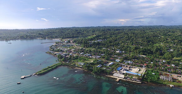
Western Province is the largest province in Papua New Guinea by area. It shares a land border with the Indonesian province of Papua and a sea border with Australia. There are several large rivers that run through the province, including the Fly River, PNG’s biggest, and the Strickland and Ok Tedi Rivers. Lake Murray, PNG’s largest lake, is also in the province.
Doing Business in Papua New Guinea
Western Highlands Province’s capital Mount Hagen is the third-largest city in Papua New Guinea, but it has a rural appearance, with its grass huts and terraced gardens where kaukau and other fruit and vegetables are grown in the Wahgi Valley. The people have a reputation for being industrious, goal-oriented and thrifty and they have been significant players in some key industries in PNG, notably: trucking, vehicle hire, taxis and buses, and agriculture.
Southern Highlands Province has lush, high valleys sandwiched between limestone peaks. Most of the natural vegetation is rainforest, with alpine woods and grasslands above 3000 metres. Swamps occur at all levels.
Sandaun Province (formerly West Sepik) is the outer province of Papua New Guinea. It is on the border of West Papua, which is Indonesia. The capital, Vanimo, is only 30 kilometres from the Indonesian border, which is closed to tourists. The province is the site of the headwaters of the Sepik River, which is covered in thick, forested mountains.
Oro Province is located to the east of the Owen Stanley mountain range, the barrier that separates the western and eastern parts of New Guinea.
Most of the rest of the province’s geography is dominated by the Sepik River, one of the largest rivers in the world in terms of water flow.The Sepik, which flows 1126 kilometres from source to the sea, frequently floods and the river’s level can alter by as much as five metres over the course of the year. The southern areas of the province are taken up by the Hunstein Ranges.
New Ireland is one of the northernmost islands of Papua New Guinea. It is long, narrow and mountainous, with vast stretches of white sandy beaches. The island is part of the Bismarck Archipelago and although 360 km in length, the width is never more than 40 km.
The National Capital District (NCD) is Port Moresby. It is both a city and a district and the gateway to Papua New Guinea – the nation’s capital, centre of politics, trade and commerce. The city, which has become a growing and bustling metropolitan area, is dry, dusty and brown duringthe winter months, but is wet, humid and overgrown in summer. It is located on the southern coast of the country, surrounded by part of Fairfax Harbour.
Morobe is Papua New Guinea’s most populous province and the gateway to the interior of the country.
Also referred to as the Admiralty Islands, Manus Province comprises 18-plus islands covering about 2000 square kilometres of land and 220,000 square kilometres of sea. It is Papua New Guinea’s smallest province. Manus Island is the largest of the islands in the province.